Destinations › South America › Lima
Lima
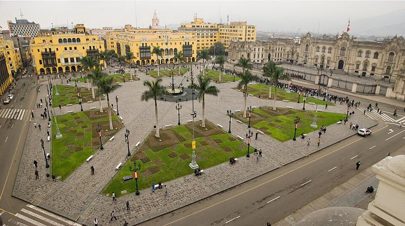
Photo: JulioKuLu · CC BY-SA 4.0

CountryPeru
RegionSouth America
Best monthsJan–May, Nov–Dec
Nearest airportsLIM · Jorge Chávez International Airport · 9 km
About
Lima is the capital and largest city of Peru, as well as a primate city. It is located in the valleys of the Chillón, Rímac and Lurín Rivers, in the desert zone of the central coastal part of the country, overlooking the Pacific Ocean.
Source: Wikipedia (CC BY-SA 4.0)
When to go
In Lima the warmest month is February (average high 28°) and the coolest is August (19°). Most rainy days come in August. Best months to visit: Jan–May, Nov–Dec.
Highlights
From OpenStreetMap records, by distance from the centre.
- Museo de la Basílica Catedral de LimaMuseum · 92 m
- Pinacoteca Pancho FierroMuseum · 93 m
- Piedra basal andinaSight · 100 m
- Patio de Honor del Palacio de GobiernoSight · 103 m
- Museo del Palacio Arzobispal de LimaMuseum · 106 m
- Museo del PiscoMuseum · 113 m
- Catedral de limaSight · 121 m
- Salón de Jorge BasadreSight · 126 m
- Catedral de LimaSight · 131 m
- Gran HallSight · 132 m
- Salón DoradoSight · 144 m
- Palacio Nacíonal de GobiernoSight · 146 m
For families with children
Parks, beaches and child-friendly places.
- Plazuela del BaratilloNature & park · 489 m
- Parque de La MurallaNature & park · 491 m
- Plaza José Faustino Sánchez CarriónNature & park · 676 m
- Parque de la DemocraciaNature & park · 742 m
- Parque de la Cultura Doctor Luis Alberto SánchezNature & park · 822 m
- Parque UniversitarioNature & park · 913 m
- Plazuela PresaNature & park · 1.0 km
- Plazuela MonserrateNature & park · 1.1 km
Average monthly temperature (°C)
| Jan | Feb | Mar | Apr | May | Jun | Jul | Aug | Sep | Oct | Nov | Dec | |
|---|---|---|---|---|---|---|---|---|---|---|---|---|
| High | 27 | 28 | 28 | 25 | 23 | 20 | 20 | 19 | 20 | 21 | 22 | 24 |
| Low | 20 | 21 | 20 | 19 | 17 | 17 | 16 | 15 | 15 | 16 | 17 | 19 |
| Rainy days | 1 | 1 | 1 | 0 | 1 | 2 | 3 | 4 | 3 | 1 | 0 | 0 |
Climate data: Wikipedia (CC BY-SA)